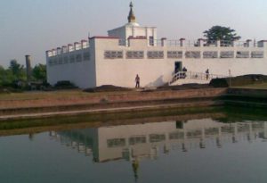
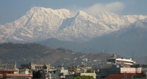
Nepal takes great pride for being home to Mount Everest, the world’s highest mountain peak, which stands at 8,848 metres above sea level. But questions are frequently raised regarding its height, and they draw the attention of the bodies concerned, trigger discussions and debates and make media headlines.
And finally, to make all confusions about the height of the peak called Sagarmatha in Nepali clear, the government has already begun homework to (re) measure its height on its own for the first time, but works are yet to gather momentum.
Officials at the Survey Department under the Ministry of Land Reform and Management admitted that though initial–phase field works for measuring the peak have already kicked off, the measurement process has failed to gain momentum due to technical reasons.
Differing views, opinions, and claims about the height of Mt Everest have prompted the government to go with a process on its own to determine the official and accurate figure.
Various claims and differing views and opinions about its height, Nepal not being able to present official figures on its own, varied measurement data presented by India and China sparking disputes at the international level and unofficial reports about the change in its height following the 2015 April earthquake have led to confusion over the height of the world’s tallest peak, although the official height is 8,848 metres to date.
Bearing all these in mind, the Department is in the process of determining the exact height and current positioning of the mountain.
It was rumoured that the devastating quake may have impacted the peak, leading to a slight change (decrease) in its height.
The Department, before starting the process to measure the peak’s height, had invited experts/ scientists concerned from India, China and Italy to a two-day international seminar held on December 11-12 last year to discuss about the measurement process. The work procedure was prepared based on the suggestions made by the seminar.
Prof Roger Witham from Colorado University and the chief of the Survey of India, who were present at the discussion, said they were happy to hear that Nepal was going to determine the height on its own, pledging all possible technical support to this regard, as stated by Department chief survey officer Sushil Dangol, who is the coordinator of the Mt Everest Measurement Secretariat.
Nepal had summoned international experts for consultation on the issue as it wanted to make the measurement unquestionable and all to accept it, he added. Prior to this, the then Survey of India in 1954 had measured the peak’s height and put it at 8,848 metres, which Nepal has officially recognised to date, and this figure has been established as the official height of Mt Everest globally.
Since then, surveys conducted at different times by different agencies to measure the height have ended up offering differing data.
According to the Department, a home team on October 24 last year had been in Solukhumbu to find out the control points that the Indian team in 1954 had used to measure the peak’s height. Such points were reportedly fixed at eight locations in Solukhumbu, two each in Khotang and Dolakha districts.
The Nepali team has so far found the points fixed at four locations in Solukhumbu. Search for the points fixed at other places is underway. The Department looks forward to finishing the measurement works of the initial phase within the next two years.
A 13-member team has already left for Madar along the Nepal-India border in Siraha for leveling work. The Survey of India will do all the leveling works up to Madar, and the Nepali team will take up the remaining works right from there.
The Department expects to complete the leveling task from Siraha to Okhaldhunga within the current fiscal year. It hopes to bring a preliminary report about the measurement of the peak in the next two years. Leveling works are going on from Salleri of Solukhumbu to Bansbari of Udaypur. Works are on to find out whether the April quake caused effects on the road leveling.
The Department’s gravity machine is dysfunctional, and it is yet to decide whether to purchase a new one or borrow it from somewhere. But the budget issue matters – if there is budget, it will have a new machine, otherwise, works will be done through a borrowed one.
The Department is using three methods to measure the mountain–direct measurement, triangulation and gravity metre.
Likewise, global positioning system (GPS) is also used in measuring the mountain and China had in 2005 measured the height of Mt Everest based on the same technology and set it to be at around 8,844 meters, but the results failed to get international acceptance.
“The Department is using a multi-method-based measurement technology in a bid to come up with indubitable findings, and the help of climbers is necessary to undertake measurement works at higher altitudes of the peak,” Dangol said, adding that discussion in this regard was underway.
It is favourable for measuring the peak only twice in a season. However, it is not certain that the measurement will conclude within the expected timeframe as untoward incidents such as natural disasters could have a significant impact on such efforts, experts say.
There is no budgetary constraint for the project. It will cost around Rs. 250 million to undertake this mission.
The government has allocated Rs. 20 million under the initial phase for this noteworthy project. Earlier in 2011, the Department had prepared a working procedure for re-measuring the mountain, but budget issues hampered further progress.
According to joint spokesperson at the Ministry of Land Reform and Management Punya Bikram Poudel, the government has assured the allocation of the remaining budget to carry out the measurement works.
Talking to RSS, he said the ministry had last year proposed to conduct the (re) measurement of the peak with the use of local human and other resources, and the government had put the project in top priority in the budget speech and in its policies and progammes, and the ministry had proceeded with the project accordingly.
Everest’s height was first measured at 8,840 metres above sea level in 1856 by a team led by George Everest, who served as the Surveyor General of India from 1830 to 1843. The peak was named Mount Everest in honour of its first surveyor. Later in 1955, the figure was increased by eight metres and has been established as the official height to date. Source: RSS
Feb. 25, 2018